
About the Island
Saint Martin, also known as Sint Maarten, is one of the Leeward Islands of the Lesser Antilles and is located in the Northeast Caribbean, bordering the Atlantic Ocean. The Lesser Antilles are volcanic islands, formed where the Atlantic Plate is pushed beneath the Caribbean Plate. The island was formed about 20 million years ago, and subsequently submerged beneath the sea and was capped with limestone rock, which is now clearly visible in many parts of the island. It is significantly less mountainous than newer islands, such as nearby Saba, but does have a range of small mountains, the tallest being Pic Paradis at 424 meters.
Saint Martin is approximately 87 square kilometers in size and ownership is divided between France (Saint Martin) and the Netherlands Antilles (Sint Maarten), with France occupying the northern 60% of the island. The population is approximately 80,000, with a majority living on the Dutch side. There are a few neighboring islets, primarily on the French side, the largest being Tintamarre and Ilet Pinel.
Like the other Lesser Antilles, Saint Martin was never connected to a continent. Subsequently, it has a relatively low diversity of native fauna, particularly those that cannot fly. During the colonial period most native habitats were destroyed for agriculture, including deforestation of the interior and the draining of mangrove wetlands. It is presumed that at least most of the current forests are secondary growth. The introduction of non-native animals, both accidental (rats, mice) and deliberate (livestock, mongoose) has also been implicated in the destruction of habitat and the extinction of native species. More recently, development for tourism has resulted in further habitat destruction and degradation of habitats such as the lagoon and the numerous salt ponds on the island.
There are a variety of habitats on the island. Without peaks high enough to support a cloud forest, the highlands are primarily tropical deciduous forest, where many trees lose leaves during the dry season. Dry scrubland also makes up a good deal of the interior of the island, particularly in areas that are used as pasture for goats or cattle. There are numerous salt ponds on the island, and most are ringed with mangrove wetlands. While there are dry gulches that may fill temporarily after strong rains, there are no permanent rivers or significant fresh water ponds. Beaches and rocky shorelines ring the island, and in areas that are not developed, littoral (seaside) forest or scrub can be found. There is a large, enclosed lagoon in the southwest part of the island. In the seas surrounding the island, a mix of sand, seagrass beds and coral reefs can be found.
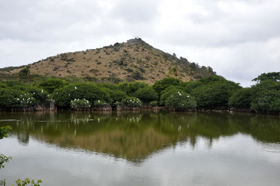
Mangroves filled with roosting egrets surround the salt pond Étang de Cimetiere near Grand Case. Behind it, Smith Hill is covered with dry scrubland.
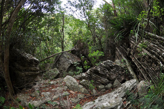
Highland forests can be quite dense, but gullies like this one on Hope Hill almost never have running water and are typically the easiest way to access the forests in areas where there are no trails.